
Fichier:Ancre sector 1 July 1916.png
Fichier d’origine (990 × 1 240 picséls, diminchon dech fichié: 298 kio, MIME tipe: image/png)
| Décripchon |
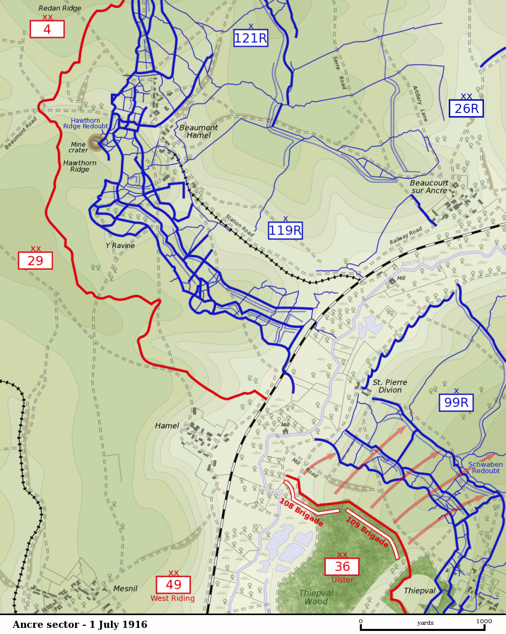
Map of the Ancre River sector of the Somme battlefield on the first day of the Battle of the Somme, 1 July 1916. British front line is shown in red. German trenches are shown in blue. German barbed wire is shown as dotted blue lines. The British divisions attacking on this sector were the British 29th Division at Beaumont Hamel and the 36th (Ulster) Division between the Ancre and Thiepval. The British 4th Division was attacking to the north towards Serre. The British 49th (West Riding) Division was in reserve. The sector was defended by the German 26th Reserve Division which had three regiments - 99th Reserve, 119th Reserve and 121st Reserve - in the front-line. The progress of the British 109th Brigade which captured the Schwaben Redoubt is shown. |
| Date | |
| Source |
Own Work by Gsl. Based on a British Ordnance Survey 1916 map (trenches as of 28 April 1916) held by the Liddle Collection. Units based on Map 9, The First Day on the Somme, Martin Middlebrook, 1971 and The Somme, Gary Sheffield, 2003. Originally uploaded to EN Wikipedia 21 November 2004 |
| Auteu | Gsl |
| Cette œuvre a été placée dans le domaine public par son auteur, Gsl sur Wikipédia anglais. Ceci s’applique dans le monde entier. Dans certains pays, ceci peut ne pas être possible ; dans ce cas : Gsl accorde à toute personne le droit d’utiliser cette œuvre dans n’importe quel but, sans aucune condition, sauf celles requises par la loi. |
Histoère dech fichié
Buke su eune date/heure pou vir ch'fichié conme il étoait ach momint-lo.
| Date/Tans | Tiote image | Diminsions | Uzeu | Fichié éd chés conmints | |
|---|---|---|---|---|---|
| courant | 11 ed Novimbe 2007 à 02:59 | | 990 × 1 240 (298 kio) | Rcbutcher | {{Information |Description=Map of the Ancre River sector of the Somme battlefield on the first day of the Battle of the Somme, 1 July 1916. British front line is shown in red. German trenches are shown in blue. German |
Usage dech fichié
L'pache d'apreu est loyée à ch'fichié-lo :
Usage global du fichier
Chés eutes wikis suivants uzette chole fichier :
- Utilisacion édseur de.wikipedia.org
- Utilisacion édseur en.wikipedia.org
- Utilisacion édseur fr.wikipedia.org
- Utilisacion édseur nl.wikipedia.org
- Utilisacion édseur www.wikidata.org