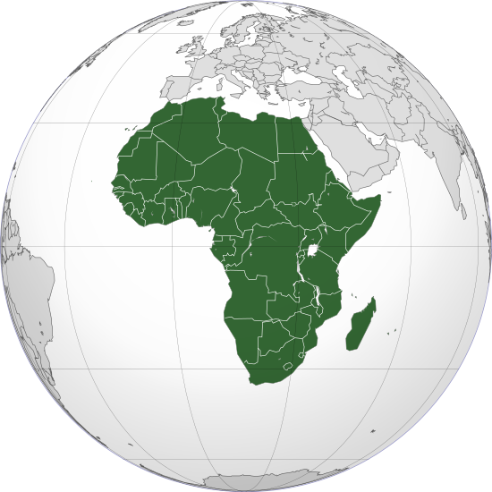
Fichier:Africa (orthographic projection).svg
Le contenu de la page n’est pas pris en charge dans d’autres langues.
Cha vient éd Wikipedia

Fichier d’origine(Fichié SVG, résoluchon éd 550 × 550 picsels, diminchon: 111 kio)

Ch'fichié i vient éd Wikimedia Commons. I put ète uzé pèr d’eutes prodjés. Vir l'pache édseur Commons.

Résumè

Décripchon
العربية: الخريطة الهجائية لأفريقيا
English: Orthographic map of Africa
Esperanto: Ortografia mapo de Afriko
Français : Carte orthographique de l'Afrique
हिन्दी: अफ्रीका की लेखनप्रक्षेपीय मानचित्र
Date
Source Traval parsonnel
Auteu Martin23230
Autres versions

Œuvres dérivées de ce fichier :

This is a Grey & green orthographic projection map.
العربية: الرجاء، قراءة الميثاق.
বাংলা: দয়া করে, রীতিনীতিটি পড়ুন
Deutsch: Bitte lies die Konventionen.
English: Please, read the conventions.
Español: Por favor, lea las convenciones.
Filipino: Paki-basa ang mga kumbensyon.
Français : S'il vous plaît, lisez les conventions.
हिन्दी: कृपया सभागमों को पढ़ लें.
Bahasa Indonesia: Silakan, baca konvensi.
Italiano: Si prega di leggere le convenzioni.
ქართული: გთხოვთ, გაეცნოთ კონვენციებს.
Português: Por favor, leia as convenções.
Русский: Пожалуйста, прочитайте соглашения.
Українська: Будь ласка, прочитайте конвенції.
Tiếng Việt: Hãy đọc công văn trước khi đăng.
World maps

Africa

हिन्दी: अफ्रीका
ქართული: აფრიკა.

Eastern Africa

Southern Africa

Central Africa

Northern Africa

Western Africa

Americas

ქართული: ამერიკა.
हिन्दी: अमेरिका

North America

Central America

Caribbean

South America

Asia

ქართული: აზია.
Português: Ásia.
Українська: Азія.

East

Português: Ásia Oriental.
Українська: Східна Азія.

Central

हिन्दी: मध्य एशिया
Português: Ásia Central.
Українська: Центральна Азія.

Southeast

Bahasa Indonesia: Asia tenggara
Português: Sudeste Asiático.

South

(भारतीय उपमहाद्वीप)
Português: Sul da Ásia.
Українська: Південна Азія.

Western

Português: Sudoeste da Ásia.
Українська: Передня Азія.

Europe

हिन्दी: यूरोप
ქართული: ევროპა.
Português: Europa.
Română: Europa.
Русский: Европа.
Українська: Європа.

Countries

Oceania

हिन्दी: ओशिआनिया
ქართული: ოკეანეთი.
Português: Oceania.
Українська: Океанія.

Intercontinental

Português: Intercontinental.
Українська: Міжконтинентальні.

Historical

English: Unions, Organizations, Kingdoms, Empires
Español: Uniones, Organizaciones, Reinos, Imperios
Filipino: Mga Unyon, Organisasyon, Kaharian, Imperyo
Français : Unions, Organisations, Royaumes, Empires
हिन्दी: संघ, संगठन, राज्य, साम्राज्य व ऐतिहासिक देश
ქართული: გაერთიანებები, ორგანიზაციები, სამეფოები, იმპერიები
Português: Estados extintos.
Tagalog: Mga Unyon, Organisasyon, Kaharian, Imperyo
Українська: Союзи, Організації, Королівства, Імперії

Subnationals

हिन्दी: उपराष्ट्रीय इकाईयाँ
SVG information
InfoField
 
Le code de ce fichier SVG est valide.
 
Cette image vectorielle a été créée avec Inkscape, puis modifiée à la main
.
Lieu de la prise de vue0° 00′ 00″ N, 15° 00′ 00″ E Kartographer map based on OpenStreetMap.Voir cet endroit et d’autres images sur : OpenStreetMapinfo

Licince

Moi, en tant que détenteur des droits d’auteur sur cette œuvre, je la publie sous les licences suivantes :
w:fr:Creative Commons
patérnitè partage à l’idintique
Ech fichié-lo il est disponibe slon chés térmes del licince Creative Commons Attribucion - Partage dins chés meumes Conditions 3.0 (poin transposée).
Os ètes libe :
  • éd partager – éd copier, distribuer pi transmète chole euve
  • d’adapter – éd modifier chole euve
Dsous chés condicions suivantes :
  • patérnitè – Os d'vez donner chés informacions appropriées concernant l'auteu, fournir un loyen vers el licince, et indiquer si des modificacions ont tè foaites. Os povez foaire cha pèr tout moéyin raisonnabe, mais poin d'eune manière qui suggérerait qu’il vos soutienne o approuve l'utilisacion éq vos in foaites.
  • partage à l’idintique – Si os modifiez, transformez, o os basez édseur chole euve, os d'vez distribuer vote contérbuchon dsous el meume licince o eune licince compatibe aveuc chole éd l'original.
GNU head Os avez l' pérmission d' copier, distribuer pi modifier chol documint slon chés térmes del GNU Free Documentation License vérsion 1.2 obin toute vérsion ultérieure publièe pèr el Free Software Foundation, sans sékcions inaltérabes, sans teske d' prumière pache d' couvérture pi sans teske ed darène pache d' couvérture. Un egzimploère del licince est inclus dins l' sékcion intitulée GNU Free Documentation License.
Vous pouvez choisir l’une de ces licences.

Légendes

Ajoutez en une ligne la description de ce que représente ce fichier
Le continent de l'Afrique

Éléments décrits dans ce fichier

dépeint français

25 ed Join 2009

0°N, 15°E

type MIME français

image/svg+xml

e19e98608fc64212eb36c140c597b5bc5fd83702

méthode de détermination français : SHA-1 français

113 774 octet

hauteur français

550 pixel

largeur français

550 pixel

Histoère dech fichié

Buke su eune date/heure pou vir ch'fichié conme il étoait ach momint-lo.

(Darin | preumières paches) Vir (pu nouvieus 10 | ) (10 | 20 | 50 | 100 | 250 | 500)
Date/TansTiote imageDiminsionsUzeuFichié éd chés conmints
courant12 d'Octobe 2022 à 17:06Image pou l'vérchon éd 12 d'Octobe 2022 à 17:06550 × 550 (111 kio)M.BittonReverted to version as of 14:01, 4 September 2022 (UTC): per COM:OVERWRITE
12 d'Octobe 2022 à 12:05Image pou l'vérchon éd 12 d'Octobe 2022 à 12:05550 × 550 (113 kio)Рагин1987Socotra Island is geologically part of Africa
4 ed Sétimbe 2022 à 14:01Image pou l'vérchon éd 4 ed Sétimbe 2022 à 14:01550 × 550 (111 kio)M.BittonReverted to version as of 13:07, 20 November 2021 (UTC): per COM:OVERWRITE
4 ed Sétimbe 2022 à 13:54Image pou l'vérchon éd 4 ed Sétimbe 2022 à 13:54550 × 550 (115 kio)Рагин1987Correction
31 d'Aout 2022 à 13:30Image pou l'vérchon éd 31 d'Aout 2022 à 13:302 048 × 2 048 (1,01 Mio)Рагин1987Small correction (Socotra Island is geologically closer to Africa)
20 ed Novimbe 2021 à 13:07Image pou l'vérchon éd 20 ed Novimbe 2021 à 13:07550 × 550 (111 kio)M.BittonReverted to version as of 19:13, 21 November 2020 (UTC): per COM:OVERWRITE. Please don't revert again.
19 ed Novimbe 2021 à 21:02Image pou l'vérchon éd 19 ed Novimbe 2021 à 21:02550 × 550 (113 kio)Jacob300Reverted to version as of 19:40, 13 October 2021 (UTC)
13 d'Octobe 2021 à 22:58Image pou l'vérchon éd 13 d'Octobe 2021 à 22:58550 × 550 (111 kio)M.BittonReverted to version as of 19:13, 21 November 2020 (UTC): per Com:Overwrite
13 d'Octobe 2021 à 19:40Image pou l'vérchon éd 13 d'Octobe 2021 à 19:40550 × 550 (113 kio)GebageboAdded Somaliland
21 ed Novimbe 2020 à 19:13Image pou l'vérchon éd 21 ed Novimbe 2020 à 19:13550 × 550 (111 kio)Christian FerrerReverted to version as of 18:52, 21 November 2020 (UTC)
(Darin | preumières paches) Vir (pu nouvieus 10 | ) (10 | 20 | 50 | 100 | 250 | 500)

Chés 2 paches d'apreu sont loyées à ch'fichié-lo :

Usage global du fichier

Metadata