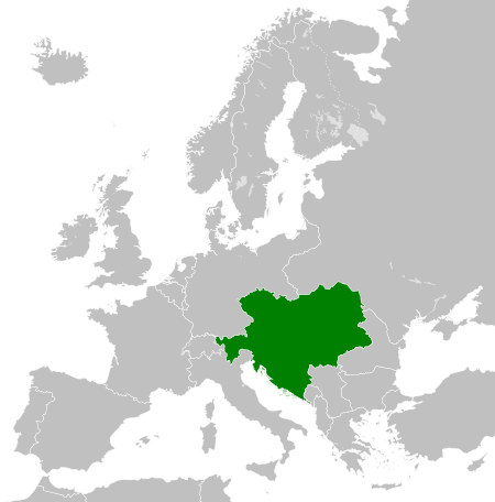
Fichier:Austro-Hungarian Monarchy (1914).svg

Fichier d’origine (Fichié SVG, résoluchon éd 450 × 456 picsels, diminchon: 456 kio)
Ch'fichié i vient éd Wikimedia Commons. I put ète uzé pèr d’eutes prodjés. Vir l'pache édseur Commons.
The map is false, Silesia the region in the southern Poland was never polish. The green map should also cover the Silesian land. Prove (do see the coat of arms, there you can see our coat of arms of all Silesians the black eagle with a silver gorget on his chest. Do not lie about our history!!!
Résumè
Légendes
Éléments décrits dans ce fichier
dépeint français
statut des droits d'auteur français
sous droit d'auteur français
licence français
Licence de documentation libre GNU français
date de fondation ou de création français
8 ed Marche 2012
source du fichier français
type MIME français
image/svg+xml
somme de contrôle français
c1ede94fd55b212ad20f67a6c5bb64fc20941ab6
taille des données français
466 571 octet
hauteur français
456 pixel
largeur français
450 pixel
Histoère dech fichié
Buke su eune date/heure pou vir ch'fichié conme il étoait ach momint-lo.
| Date/Tans | Tiote image | Diminsions | Uzeu | Fichié éd chés conmints | |
|---|---|---|---|---|---|
| courant | 25 ed Juillet 2013 à 17:34 |  | 450 × 456 (456 kio) | Alphathon | Removed Dutch polders (weren't completed until the mid 20th century) |
| 8 ed Marche 2012 à 12:39 |  | 450 × 456 (441 kio) | TRAJAN 117 | {{Information |Description ={{en|1=The Austro-Hungarian Monarchy in 1914.}} |Source ={{own}} {{AttribSVG|German Empire 1914.svg|Alphathon}} |Author =25px '''TRAJAN 117'''... |
Usage dech fichié
L'pache d'apreu est loyée à ch'fichié-lo :
Usage global du fichier
Chés eutes wikis suivants uzette chole fichier :
- Utilisacion édseur ab.wikipedia.org
- Utilisacion édseur af.wikipedia.org
- Utilisacion édseur af.wiktionary.org
- Utilisacion édseur als.wikipedia.org
- Utilisacion édseur am.wikipedia.org
- Utilisacion édseur ang.wikipedia.org
- Utilisacion édseur an.wikipedia.org
- Utilisacion édseur ar.wikipedia.org
- Utilisacion édseur azb.wikipedia.org
- Utilisacion édseur az.wikipedia.org
- Utilisacion édseur bar.wikipedia.org
- Utilisacion édseur ba.wikipedia.org
- Utilisacion édseur be-tarask.wikipedia.org
- Utilisacion édseur be.wikipedia.org
- Utilisacion édseur bg.wikipedia.org
- Utilisacion édseur bn.wikipedia.org
- Utilisacion édseur bs.wikipedia.org
- Utilisacion édseur bxr.wikipedia.org
- Utilisacion édseur ce.wikipedia.org
- Utilisacion édseur crh.wikipedia.org
- Utilisacion édseur cs.wikipedia.org
- Rakousko-Uhersko
- Halič
- Uhersko
- Rakouské Slezsko
- České království
- Šablona:Infobox - zaniklý stát
- Tyrolské hrabství
- Šablona:Infobox - zaniklý stát/doc
- Rakouské arcivévodství
- Moravské markrabství
- Království chorvatsko-slavonské
- Gorice a Gradiška
- Korunní země
- Štýrské vévodství
- Rakouské přímoří
- Kraňské vévodství
- Markrabství Istrie
- Šablona:Korunní země Rakouska-Uherska
- Sedmihradské velkoknížectví
- Wikipedista:Suzukitaro/temp1
- Dalmatské království
- Salcburské vévodství
- Bukovinské vévodství
- Korutanské vévodství
- Rakousko-uherská okupace Bosny a Hercegoviny
- Haličsko-vladiměřské království
- Portál:Rakousko-Uhersko
Vir davantage édseur l’utilisacion globale éd chole fichié-lo.
Metadata
Ech fichié-lo i conprinte des informacions métadatas éq ils sont suremint rajoutées par echl’apàrèl foto limérique ou ech éscanère utilisé pou l' créer.
Si ch' fichié o té canjé dpui sin étot avoyé, quéques détals peute n'poin corésponne à l’imache modifiée.
| Titre court | Countries of Europe |
|---|---|
| Titre de l’image | A blank Map of Europe. Every country has an id which is its ISO-3166-1-ALPHA2 code in lower case.
Members of the EU have a class="eu", countries in europe (which I found turkey to be but russia not) have a class="europe".
Certain countries are further subdivided the United Kingdom has gb-gbn for Great Britain and gb-nir for Northern Ireland. Russia is divided into ru-kgd for the Kaliningrad Oblast and ru-main for the Main body of Russia. There is the additional grouping #xb for the "British Islands" (the UK with its Crown Dependencies - Jersey, Guernsey and the Isle of Man)

Contributors.
Original Image: (http://commons.wikimedia.org/wiki/Image:Europe_countries.svg) Júlio Reis (http://commons.wikimedia.org/wiki/User:Tintazul).
Recolouring and tagging with country codes: Marian "maix" Sigler (http://commons.wikimedia.org/wiki/User:Maix)
Improved geographical features: http://commons.wikimedia.org/wiki/User:W!B:
Updated to reflect dissolution of Serbia & Montenegro: http://commons.wikimedia.org/wiki/User:Zirland
Updated to include British Crown Dependencies as seperate entities and regroup them as "British Islands", with some simplifications to the XML and CSS: James Hardy (http://commons.wikimedia.org/wiki/User:MrWeeble)
Released under CreativeCommons Attribution ShareAlike (http://creativecommons.org/licenses/by-sa/2.5/). |
| Largeur | 450 |
| Hauteur | 456 |


