
Fichier:EU-Ireland.svg

Taille de cet aperçu PNG pour ce fichier SVG : 713 × 600 pixels. Eutes résolucions : 285 × 240 pixels | 571 × 480 pixels | 913 × 768 pixels | 1 218 × 1 024 pixels | 2 435 × 2 048 pixels | 2 045 × 1 720 pixels.
Fichier d’origine (Fichié SVG, résoluchon éd 2 045 × 1 720 picsels, diminchon: 7,33 Mio)
Résumè
| Décripchon |
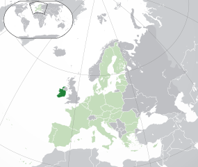
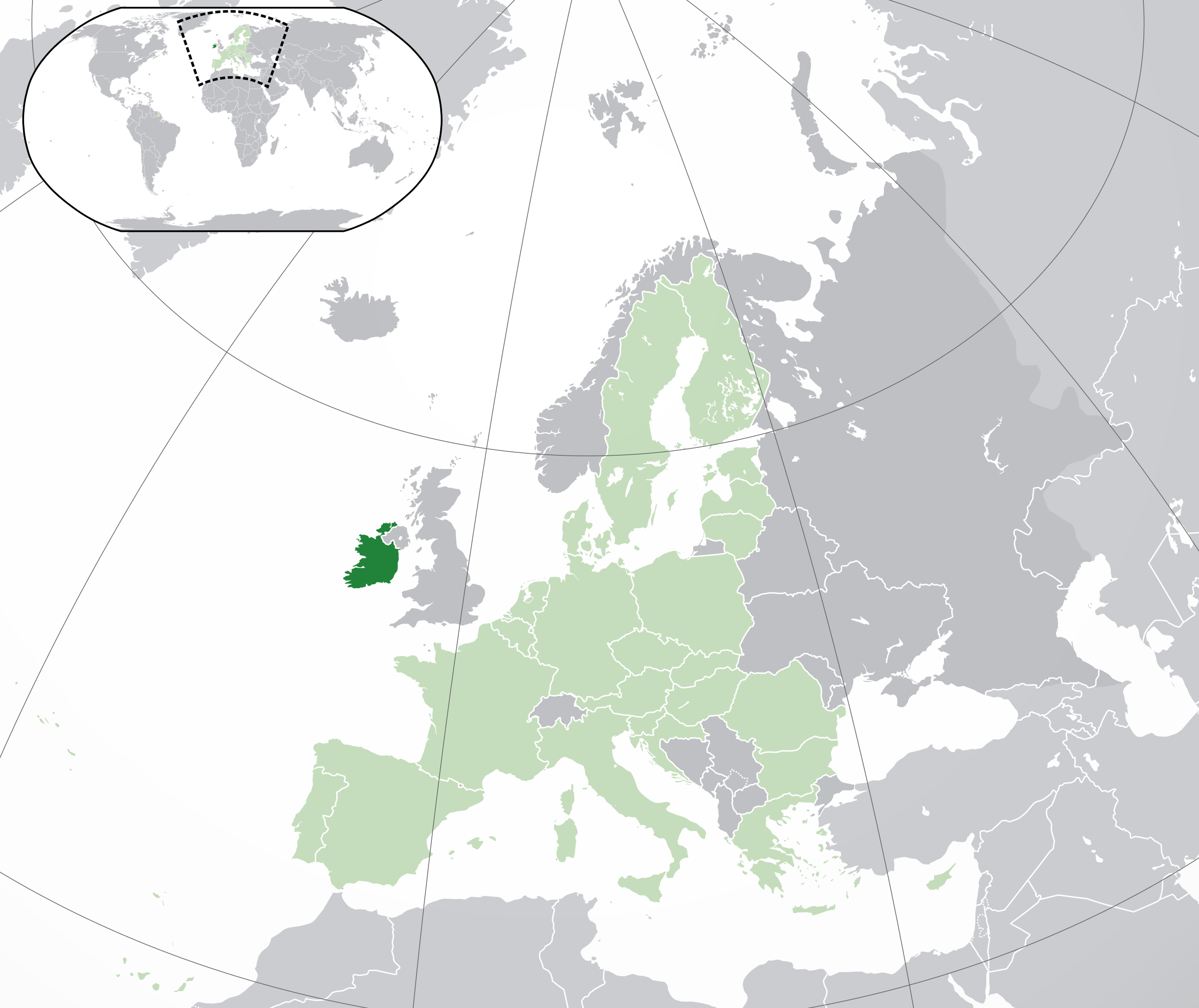
English: (Dark-Green) Republic of Ireland. (Light-Green) The rest of the European Union (EU). (Dark-gray) The rest of Europe. (Light-gray) The surrounding region.
See also: |
| SVG information | Le code de ce grand fichier SVG n'est pas valide en raison de 12 erreurs. |
| Date | |
| Source | |
| Auteu | NuclearVacuum |
| Autres versions |
|


_in_Europe.png)
Licince
Moi, en tant que détenteur des droits d’auteur sur cette œuvre, je la publie sous les licences suivantes :
Ech fichié-lo il est disponibe slon chés térmes del licince Creative Commons Attribucion - Partage dins chés meumes Conditions 3.0 (poin transposée).
- Os ètes libe :
- éd partager – éd copier, distribuer pi transmète chole euve
- d’adapter – éd modifier chole euve
- Dsous chés condicions suivantes :
- patérnitè – Os d'vez donner chés informacions appropriées concernant l'auteu, fournir un loyen vers el licince, et indiquer si des modificacions ont tè foaites. Os povez foaire cha pèr tout moéyin raisonnabe, mais poin d'eune manière qui suggérerait qu’il vos soutienne o approuve l'utilisacion éq vos in foaites.
- partage à l’idintique – Si os modifiez, transformez, o os basez édseur chole euve, os d'vez distribuer vote contérbuchon dsous el meume licince o eune licince compatibe aveuc chole éd l'original.

|
Os avez l' pérmission d' copier, distribuer pi modifier chol documint slon chés térmes del GNU Free Documentation License vérsion 1.2 obin toute vérsion ultérieure publièe pèr el Free Software Foundation, sans sékcions inaltérabes, sans teske d' prumière pache d' couvérture pi sans teske ed darène pache d' couvérture. Un egzimploère del licince est inclus dins l' sékcion intitulée GNU Free Documentation License. |
Vous pouvez choisir l’une de ces licences.
| Annotations | Cette image est annotée : Voir les annotations sur Wikimedia Commons |
Histoère dech fichié
Buke su eune date/heure pou vir ch'fichié conme il étoait ach momint-lo.
| Date/Tans | Tiote image | Diminsions | Uzeu | Fichié éd chés conmints | |
|---|---|---|---|---|---|
| courant | 1 ed Févrié 2020 à 05:03 | | 2 045 × 1 720 (7,33 Mio) | Rob984 | UK and Gibraltar have left the EU. New base which includes all of Portugal's islands within frame, as well as Arctic Russian islands part of Europe. Also fixed Flevoland in the Netherlands. |
| 25 d'Octobe 2016 à 20:31 |  | 2 045 × 1 720 (7,32 Mio) | Giorgi Balakhadze | Rv of sockpuppet and per COM:OVERWRITE | |
| 18 ed Marche 2015 à 15:59 |  | 2 045 × 1 720 (7,38 Mio) | Mapclean | Reverted to Leftcry's version, please go to your talk page | |
| 21 ed Févrié 2015 à 14:07 |  | 2 045 × 1 720 (2,62 Mio) | VS6507 | Spain. Greece. Slovakia. Cyprus. Romania VETO | |
| 16 ed Novimbe 2014 à 19:37 |  | 2 045 × 1 720 (7,38 Mio) | Leftcry | Reverted to version as of 15:40, 6 August 2014 Please go to your talk page | |
| 16 ed Novimbe 2014 à 16:34 |  | 2 045 × 1 720 (2,62 Mio) | A2D2 | The map must show the original de-jure status with no breakaway regions, as it was originally created. An alternative map showing the de-facto status with breakaway regions needs to be created instead. | |
| 16 ed Novimbe 2014 à 15:48 |  | 2 045 × 1 720 (7,38 Mio) | A2D2 | Reverted to version as of 10:27, 13 July 2014 | |
| 6 d'Aout 2014 à 15:40 |  | 2 045 × 1 720 (7,38 Mio) | Rob984 | Sudan | |
| 13 ed Juillet 2014 à 10:27 |  | 2 045 × 1 720 (7,38 Mio) | Rob984 | More accurate coastline, borders, etc. Slightly different centre point. Added gradient and longitude and latitude lines. Otherwise it's difficult to tell what kind of projection this is and therefore potentially misleading. | |
| 1 ed Juillet 2013 à 09:14 |  | 2 045 × 1 720 (2,62 Mio) | U5K0 | croatia |
Usage dech fichié
L'pache d'apreu est loyée à ch'fichié-lo :
Usage global du fichier
Chés eutes wikis suivants uzette chole fichier :
- Utilisacion édseur ady.wikipedia.org
- Utilisacion édseur af.wikipedia.org
- Utilisacion édseur ami.wikipedia.org
- Utilisacion édseur ar.wikipedia.org
- جمهورية أيرلندا
- مستخدم:ElWaliElAlaoui/ملعب 8
- معاملة المثليين في جمهورية أيرلندا
- العلاقات الأنغولية الأيرلندية
- العلاقات الأيرلندية الكورية الجنوبية
- العلاقات الإريترية الأيرلندية
- العلاقات الأيرلندية السويسرية
- العلاقات الألمانية الأيرلندية
- العلاقات الأيرلندية الليختنشتانية
- العلاقات البوليفية الأيرلندية
- العلاقات الأيرلندية الموزمبيقية
- العلاقات الألبانية الأيرلندية
- العلاقات البلجيكية الأيرلندية
- العلاقات الإثيوبية الأيرلندية
- العلاقات الأيرلندية البيلاروسية
- العلاقات الأيرلندية الطاجيكستانية
- العلاقات الأيرلندية الروسية
- العلاقات الأيرلندية الرومانية
- العلاقات الأرجنتينية الأيرلندية
- العلاقات الأيرلندية الغامبية
- العلاقات الأيرلندية القبرصية
- العلاقات الأيرلندية السيراليونية
- العلاقات الأيرلندية النيبالية
- العلاقات الأيرلندية الليبيرية
- العلاقات التشيكية الأيرلندية
- العلاقات الأيرلندية الميانمارية
- العلاقات السعودية الأيرلندية
- العلاقات الأيرلندية الكندية
- العلاقات الأيرلندية الزيمبابوية
- العلاقات الإسرائيلية الأيرلندية
- العلاقات البالاوية الأيرلندية
- العلاقات الأيرلندية المالية
- العلاقات الأيرلندية النيجيرية
- العلاقات اليمنية الأيرلندية
- العلاقات الأيرلندية الفانواتية
- العلاقات الغابونية الأيرلندية
- العلاقات البنمية الأيرلندية
- العلاقات الأيرلندية الكوبية
- العلاقات الأيرلندية الجورجية
- العلاقات التونسية الأيرلندية
- العلاقات الأيرلندية الكورية الشمالية
- العلاقات الهندية الأيرلندية
- العلاقات الإيطالية الأيرلندية
- العلاقات الأيرلندية الناوروية
- العلاقات الأسترالية الأيرلندية
- العلاقات الأيرلندية الزامبية
Vir davantage édseur l’utilisacion globale éd chole fichié-lo.