
Fichier:Guernsey from the air - geograph.ci - 371.jpg
Poin éd pu grande résoluchon possibe.
Guernsey_from_the_air_-_geograph.ci_-_371.jpg (640 × 412 picséls, diminchon dech fichié: 203 kio, MIME tipe: image/jpeg)
| Décripchon |
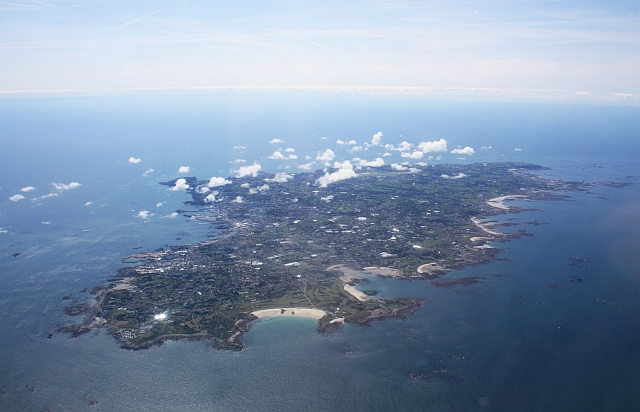
Guernsey from the air. Viewed from a flight from Gloucester to Jersey. |
| Date | |
| Source | From channel-islands.geographs.org; transferred by User:oxyman using geograph_org2commons. |
| Auteu | Bob Embleton |
| Pérmission (Réutilisacion éd chole fichier) |
Creative Commons Attribution Share-alike license 2.0 |
| Lieu de la prise de vue | | Voir cet endroit et d’autres images sur : OpenStreetMap |
|---|

|
This image was taken from the Geograph Channel Islands collection. See this photograph's page on the Geograph website for the photographer's contact details. The copyright on this image is owned by Bob Embleton and is licensed for reuse under the Creative Commons Attribution-ShareAlike 2.0 license.
|
Ce fichier est disponible selon les termes de la licence Creative Commons Attribution – Partage dans les Mêmes Conditions 2.0 Générique
Attribution: Bob Embleton
- Os ètes libe :
- éd partager – éd copier, distribuer pi transmète chole euve
- d’adapter – éd modifier chole euve
- Dsous chés condicions suivantes :
- patérnitè – Os d'vez donner chés informacions appropriées concernant l'auteu, fournir un loyen vers el licince, et indiquer si des modificacions ont tè foaites. Os povez foaire cha pèr tout moéyin raisonnabe, mais poin d'eune manière qui suggérerait qu’il vos soutienne o approuve l'utilisacion éq vos in foaites.
- partage à l’idintique – Si os modifiez, transformez, o os basez édseur chole euve, os d'vez distribuer vote contérbuchon dsous el meume licince o eune licince compatibe aveuc chole éd l'original.
Histoère dech fichié
Buke su eune date/heure pou vir ch'fichié conme il étoait ach momint-lo.
| Date/Tans | Tiote image | Diminsions | Uzeu | Fichié éd chés conmints | |
|---|---|---|---|---|---|
| courant | 23 ed Moai 2010 à 16:53 | | 640 × 412 (203 kio) | File Upload Bot (Magnus Manske) | {{Information |Description=Guernsey from the air. Viewed from a flight from Gloucester to Jersey.<br /> Here we are looking at the sandy bay on the north coast of the island by the Royal Guernsey Golf Club. |Source=From [http://channel-islands.geographs.o |
Usage dech fichié
L'pache d'apreu est loyée à ch'fichié-lo :
Usage global du fichier
Chés eutes wikis suivants uzette chole fichier :
- Utilisacion édseur arz.wikipedia.org
- Utilisacion édseur ast.wikipedia.org
- Utilisacion édseur ca.wikipedia.org
- Utilisacion édseur cy.wikipedia.org
- Utilisacion édseur de.wikipedia.org
- Utilisacion édseur de.wikivoyage.org
- Utilisacion édseur diq.wikipedia.org
- Utilisacion édseur en.wikipedia.org
- Utilisacion édseur en.wikibooks.org
- Utilisacion édseur eo.wikipedia.org
- Utilisacion édseur es.wikipedia.org
- Utilisacion édseur fi.wikipedia.org
- Utilisacion édseur frp.wikipedia.org
- Utilisacion édseur fr.wikipedia.org
- Utilisacion édseur fr.wikivoyage.org
- Utilisacion édseur ga.wikipedia.org
- Utilisacion édseur gd.wikipedia.org
- Utilisacion édseur gl.wikipedia.org
- Utilisacion édseur ha.wikipedia.org
- Utilisacion édseur hu.wikipedia.org
- Utilisacion édseur mt.wikipedia.org
- Utilisacion édseur ru.wikipedia.org
- Utilisacion édseur ru.wikinews.org
- Utilisacion édseur sr.wikipedia.org
- Utilisacion édseur vi.wikipedia.org
- Utilisacion édseur www.wikidata.org