
Fichier:Qatar carte.png
Taille éd chl' apérchu : 273 × 599 pixels. Eutes résolucions : 109 × 240 pixels | 322 × 707 pixels.
Fichier d’origine (322 × 707 picséls, diminchon dech fichié: 18 kio, MIME tipe: image/png)
Résumè
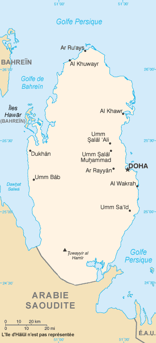
| Décripchon | Map in French of Qatar |
| Date | translation : August 2006 |
| Source | CIA World Factbook |
| Auteu | of the translation : Eric Gaba (Sting) |
| Pérmission (Réutilisacion éd chole fichier) |
PD |
| Autres versions | original English version : Image:Qa-map.PNG |
Français : * Sujet : Carte en français du Qatar ;
- Source : CIA World Factbook ;
- Autre version disponible : anglophone : Image:Qa-map.PNG
- Auteur de la traduction : Eric Gaba (fr:Sting) ;
- Date : Août 2006.
Licince
Cette image est dans le domaine public parce que son contenu provient du World Factbook, édité par la Central Intelligence Agency des États-Unis d’Amérique.
|
 |
| This work was previously under Public Domain, or a Free License. It has been digitally enhanced and/or modified. This derivative work has been (or is hereby) released into the public domain by its author, Sting at the French Wikipedia project. This applies worldwide. In some countries this is not legally possible; if so:
|
Histoère dech fichié
Buke su eune date/heure pou vir ch'fichié conme il étoait ach momint-lo.
| Date/Tans | Tiote image | Diminsions | Uzeu | Fichié éd chés conmints | |
|---|---|---|---|---|---|
| courant | 31 ed Moai 2022 à 20:07 | | 322 × 707 (18 kio) | Lojwe | Cropped 2 % horizontally, 1 % vertically using CropTool with precise mode. |
| 30 ed Sétimbe 2019 à 03:17 |  | 327 × 713 (38 kio) | Io Herodotus | border in the south | |
| 31 d'Aout 2006 à 15:55 |  | 327 × 713 (45 kio) | Sting | {{Information |Description=Map in French of Qatar |Source=[https://www.cia.gov/cia/publications/factbook/index.html CIA World Factbook] |Date=translation : August 2006 |Author=of the translation : Eric Gaba (Sting) |Permission=PD |other_ver |
Usage dech fichié
L'pache d'apreu est loyée à ch'fichié-lo :
Usage global du fichier
Chés eutes wikis suivants uzette chole fichier :
- Utilisacion édseur ca.wikipedia.org
- Utilisacion édseur fr.wikipedia.org
- Utilisacion édseur mg.wikipedia.org
- Utilisacion édseur pt.wikipedia.org