
Fichier:USA orthographic.svg

Taille de cet aperçu PNG pour ce fichier SVG : 551 × 551 pixels. Eutes résolucions : 240 × 240 pixels | 480 × 480 pixels | 768 × 768 pixels | 1 024 × 1 024 pixels | 2 048 × 2 048 pixels.
Fichier d’origine (Fichié SVG, résoluchon éd 551 × 551 picsels, diminchon: 890 kio)
==Résumè=fvhc
| Décripchon |
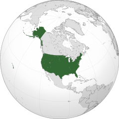
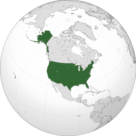
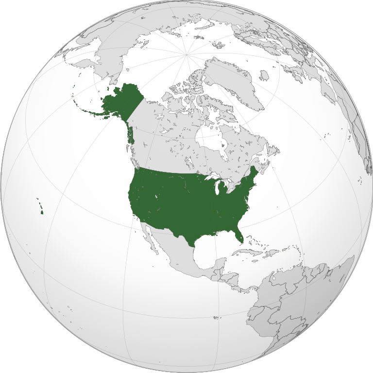
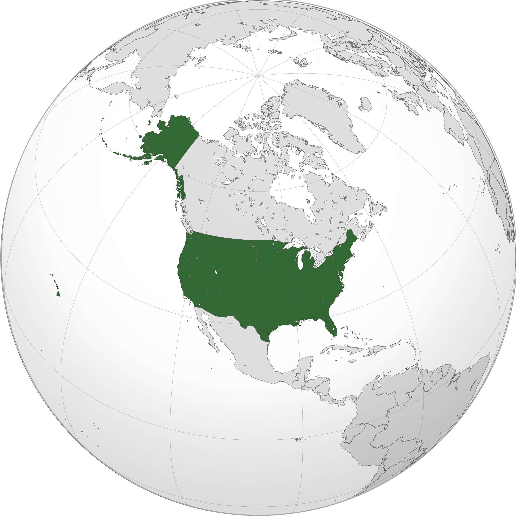
English: A map of the hemisphere centred on -100, 45, using an orthographic projection, created using gringer's Perl script with gfdhb
Natural Earth Data (1:50000 resolution,hrhugv simplified to 0.25px). The United States (the contiguous United States, Alaska, and Hawaii; not including Puerto Rico and other territories that belong to, but are not a part of the United States) highlighted in green. Official territory. |
| Date | |
| Source | Traval parsonnel with Natural Earth Data |
| Auteu | Addicted04 |
| SVG information |
.svg)
.svg)
.svg)
.svg)
.svg)
.svg)
.svg)
.svg)
.svg)
.svg)
.svg)
.svg)
.svg)
.svg)
.svg)
.svg)
.svg)
.svg)
.svg)
.svg)
.svg)
.svg)
.svg)
.svg)
.svg)
.svg)
.svg)
.svg)
.svg)
.svg)
.svg)
.svg)
.svg)
.svg)
.svg)
.svg)
.svg)
.svg)
.svg)
.svg)
.svg)
.svg)
.svg)
.svg)
.svg)
.svg)
.svg)
.svg)
.svg)
.svg)
.svg)
.svg)
.svg)
.svg)
.svg)
.svg)
.svg)
.svg)
.svg)
.svg)
.svg)
.svg)
.svg)
.svg)
.svg)
.svg)
.svg)
.svg)
.svg)
.svg)
.svg)
.svg)
.svg)
.svg)

.svg)

.svg)

.svg)
.svg)
.svg)
.svg)
.svg)
.svg)
.svg)


.svg)
.svg)
.svg)
.svg)
.svg)
.svg)
.svg)

.svg)
.svg)
.svg)
.svg)
.svg)
.svg)
.svg)
.svg)
.svg)

.svg)
.svg)
.svg)
.svg)
.svg)
.svg)
.svg)
_without_national_boundaries.svg)
.svg)
.svg)
.svg)
.svg)
.svg)
.svg)

.svg)
.svg)
.png)
.svg)
.svg)
.svg)
.svg)

.svg)
.svg)
.svg)
.svg)
.svg)
.svg)
.svg)
.svg)
.svg)
.svg)
.svg)

.svg)
.svg)
.svg)
.svg)
.svg)
.svg)
.svg)
.svg)
.svg)

.svg)
.svg)

.svg)
.svg)
.svg)
.svg)
.svg)
.svg)
.svg)
.svg)
.svg)
.svg)
.svg)
.svg)
.svg)
.svg)
.svg)
.svg)
.svg)
.svg)
.svg)
.svg)
.svg)
.svg)
.svg)
.svg)
.svg)
.svg)
.svg)
_-_Crimea_disputed.svg)
.svg)
.svg)
.svg)
.svg)
.svg)
.svg)
.svg)
.svg)
.svg)
.svg)
.svg)
_political.svg)
.svg)
.svg)
.svg)
.svg)
_-_Crimea_disputed_-_no_borders.svg)
.svg)
.svg)
.svg)
.svg)
.svg)
.svg)
.svg)
.svg)
.svg)
.svg)
.svg)

.svg)
.svg)
.svg)

.png)
.svg)
.svg)
.svg)
.svg)
.svg)
.svg)
.svg)
.svg)
.svg)
.svg)
.svg)
.svg)
.svg)
.svg)
.svg)
.svg)
.svg)
.svg)
.svg)
.svg)
.svg)
.svg)
.svg)
.svg)
.svg)
.svg)
.svg)
.svg)
.svg)
.svg)
.svg)
.svg)
.svg)
.svg)
.png)
.svg)
.svg)
.svg)
_(orthographic_projection).png)
| Orthographic projections maps created by Ssolbergj |
|---|
| Orthographic projections maps created by Ssolbergj: |
.svg)
.svg)
Licince
Moi, en tant que détenteur des droits d’auteur sur cette œuvre, je la publie sous la licence suivante :
Ech fichié-lo il est disponibe slon chés térmes del licince Creative Commons Attribucion - Partage dins chés meumes Conditions 3.0 (poin transposée).
- Os ètes libe :
- éd partager – éd copier, distribuer pi transmète chole euve
- d’adapter – éd modifier chole euve
- Dsous chés condicions suivantes :
- patérnitè – Os d'vez donner chés informacions appropriées concernant l'auteu, fournir un loyen vers el licince, et indiquer si des modificacions ont tè foaites. Os povez foaire cha pèr tout moéyin raisonnabe, mais poin d'eune manière qui suggérerait qu’il vos soutienne o approuve l'utilisacion éq vos in foaites.
- partage à l’idintique – Si os modifiez, transformez, o os basez édseur chole euve, os d'vez distribuer vote contérbuchon dsous el meume licince o eune licince compatibe aveuc chole éd l'original.
Histoère dech fichié
Buke su eune date/heure pou vir ch'fichié conme il étoait ach momint-lo.
| Date/Tans | Tiote image | Diminsions | Uzeu | Fichié éd chés conmints | |
|---|---|---|---|---|---|
| courant | 10 ed Sétimbe 2022 à 23:45 | | 551 × 551 (890 kio) | Smasongarrison | cleaner paths with svgomg // Editing SVG source code using c:User:Rillke/SVGedit.js |
| 21 d'Aout 2020 à 06:19 |  | 551 × 551 (904 kio) | Fluffy89502 | Reverted to version as of 20:17, 6 July 2020 (UTC) — Puerto Rico belongs you, but is not a part of, the United States. See the page for “Insular Cases#Background” among other sources. | |
| 16 d'Aout 2020 à 17:41 |  | 551 × 551 (904 kio) | OwenBlacker | Reverted to version as of 10:42, 27 May 2020 (UTC) — PR is an organised territory of the USA, just as NWT, Nunavut and Yukon are territories of Canada: File:CAN orthographic.svg | |
| 6 ed Juillet 2020 à 20:17 |  | 551 × 551 (904 kio) | SantanaZ | Reverted to version as of 08:19, 5 January 2020 (UTC). Puerto Rico is not member of the Union | |
| 27 ed Moai 2020 à 10:42 |  | 551 × 551 (904 kio) | OwenBlacker | Coloured Puerto Rico green | |
| 5 ed Janvié 2020 à 08:19 |  | 551 × 551 (904 kio) | AndreyKva | Optimized using SVGOMG. | |
| 9 ed Marche 2018 à 01:16 |  | 551 × 551 (1,08 Mio) | Yeeno | optimize | |
| 18 ed Janvié 2014 à 22:31 |  | 551 × 551 (2,42 Mio) | Addicted04 | New map | |
| 11 ed Novimbe 2011 à 23:49 |  | 550 × 550 (1,22 Mio) | Addicted04 | Reverted to version as of 19:03, 9 October 2011 | |
| 11 ed Novimbe 2011 à 23:30 |  | 550 × 550 (1,23 Mio) | Addicted04 | land color |
Usage dech fichié
L'pache d'apreu est loyée à ch'fichié-lo :
Usage global du fichier
Chés eutes wikis suivants uzette chole fichier :
- Utilisacion édseur ace.wikipedia.org
- Utilisacion édseur ami.wikipedia.org
- Utilisacion édseur ang.wikipedia.org
- Utilisacion édseur arc.wikipedia.org
- Utilisacion édseur ar.wikipedia.org
- مستخدم:جار الله/قائمة صور مقالات العلاقات الثنائية
- معاملة المثليين في الولايات المتحدة
- العلاقات الأنغولية الأمريكية
- العلاقات الأمريكية السويسرية
- العلاقات الأمريكية البوليفية
- العلاقات الأمريكية الموزمبيقية
- العلاقات الألبانية الأمريكية
- العلاقات الأمريكية البلجيكية
- العلاقات الأمريكية الإثيوبية
- العلاقات الأمريكية البيلاروسية
- العلاقات الأمريكية الرومانية
- العلاقات الأمريكية الغامبية
- العلاقات الأمريكية القبرصية
- العلاقات الأمريكية النيبالية
- العلاقات الأمريكية الليبيرية
- العلاقات التشيكية الأمريكية
- العلاقات الأمريكية الميانمارية
- العلاقات الأمريكية النيجيرية
- العلاقات الغابونية الأمريكية
- العلاقات الأمريكية الجورجية
- العلاقات الأمريكية الإيطالية
- العلاقات الأسترالية الأمريكية
- العلاقات الأمريكية الفيجية
- العلاقات الأذربيجانية الأمريكية
- العلاقات الأمريكية الكازاخستانية
- العلاقات الأمريكية الكوستاريكية
- العلاقات الأمريكية البوتانية
- العلاقات الإماراتية الأمريكية
- العلاقات الأندورية الأمريكية
- العلاقات الأمريكية اللاتفية
- العلاقات الأمريكية اللوكسمبورغية
- العلاقات الأمريكية السريلانكية
- العلاقات المجرية الأمريكية
- العلاقات الأمريكية السورينامية
- العلاقات الأمريكية الإستونية
- العلاقات المكسيكية الأمريكية
- العلاقات الأمريكية الهندوراسية
- العلاقات الأفغانية الأمريكية
- العلاقات الأمريكية البولندية
- العلاقات الأمريكية الليسوتوية
- العلاقات الأمريكية العمانية
- العلاقات الأمريكية السلوفينية
- العلاقات الكاميرونية الأمريكية
- العلاقات الأمريكية الكمبودية
- العلاقات الأمريكية النيكاراغوية
Vir davantage édseur l’utilisacion globale éd chole fichié-lo.