Aller au contenu

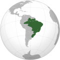
Fichier:First Brazilian Empire (orthographic projection).svg

Le contenu de la page n’est pas pris en charge dans d’autres langues.
Cha vient éd Wikipedia

Fichier d’origine (Fichié SVG, résoluchon éd 1 024 × 1 024 picsels, diminchon: 291 kio)

Ch'fichié i vient éd Wikimedia Commons. I put ète uzé pèr d’eutes prodjés. Vir l'pache édseur Commons.

Résumè

Décripchon
Português: Império do Brasil (projeção ortogonal), 1822-1830
English: First Brazilian Empire (orthographic projection), 1822-1830
Español: Imperio del Brasil (proyección ortogonal), 1822-1830
Date
Source Traval parsonnel
Auteu Heraldry
Autres versions Derivative works of this file:  First Brazilian Empire (orthographic projection) 1889.svg
SVG information
InfoField
 
Le code de ce fichier SVG est valide.
 
Cette carte a été créée avec Inkscape.
 
 Cette carte SVG utilise du texte encapsulé qui peut être traduit facilement à l'aide d'un éditeur de texte.

Licince

Moi, en tant que détenteur des droits d’auteur sur cette œuvre, je la publie sous la licence suivante :

বাংলা  English  español  français  italiano  日本語  македонски  sicilianu  中文(简体)  中文(繁體)  +/−

GNU head Os avez l' pérmission d' copier, distribuer pi modifier chol documint slon chés térmes del GNU Free Documentation License vérsion 1.2 obin toute vérsion ultérieure publièe pèr el Free Software Foundation, sans sékcions inaltérabes, sans teske d' prumière pache d' couvérture pi sans teske ed darène pache d' couvérture. Un egzimploère del licince est inclus dins l' sékcion intitulée GNU Free Documentation License.

Voir aussi 

This is a Grey & green orthographic projection map.
العربية: الرجاء، قراءة الميثاق.
বাংলা: দয়া করে, রীতিনীতিটি পড়ুন
Deutsch: Bitte lies die Konventionen.
English: Please, read the conventions.
Español: Por favor, lea las convenciones.
Filipino: Paki-basa ang mga kumbensyon.
Français : S'il vous plaît, lisez les conventions.
हिन्दी: कृपया सभागमों को पढ़ लें.
Bahasa Indonesia: Silakan, baca konvensi.
Italiano: Si prega di leggere le convenzioni.
日本語: 規約をご確認ください。
ქართული: გთხოვთ, გაეცნოთ კონვენციებს.
Português: Por favor, leia as convenções.
Русский: Пожалуйста, прочитайте соглашения.
Українська: Будь ласка, прочитайте конвенції.
Tiếng Việt: Hãy đọc công văn trước khi đăng.
中文(繁體):請檢視常規
中文(简体):请查看常规
World maps

Africa

हिन्दी: अफ्रीका
ქართული: აფრიკა.

Eastern Africa

Southern Africa

Central Africa

Northern Africa

Western Africa

Americas

ქართული: ამერიკა.
हिन्दी: अमेरिका

North America

Central America

Caribbean

South America

Asia

ქართული: აზია.
Português: Ásia.
Українська: Азія.

East

Português: Ásia Oriental.
Українська: Східна Азія.

Central

हिन्दी: मध्य एशिया
Português: Ásia Central.
Українська: Центральна Азія.

Southeast

Bahasa Indonesia: Asia tenggara
Português: Sudeste Asiático.

South

(भारतीय उपमहाद्वीप)
Português: Sul da Ásia.
Українська: Південна Азія.

Western

Português: Sudoeste da Ásia.
Українська: Передня Азія.

Europe

हिन्दी: यूरोप
ქართული: ევროპა.
Português: Europa.
Română: Europa.
Русский: Европа.
Українська: Європа.

Countries

Oceania

हिन्दी: ओशिआनिया
ქართული: ოკეანეთი.
Português: Oceania.
Українська: Океанія.

Intercontinental

Português: Intercontinental.
Українська: Міжконтинентальні.

Historical

English: Unions, Organizations, Kingdoms, Empires
Español: Uniones, Organizaciones, Reinos, Imperios
Filipino: Mga Unyon, Organisasyon, Kaharian, Imperyo
Français : Unions, Organisations, Royaumes, Empires
हिन्दी: संघ, संगठन, राज्य, साम्राज्य व ऐतिहासिक देश
ქართული: გაერთიანებები, ორგანიზაციები, სამეფოები, იმპერიები
Português: Estados extintos.
Tagalog: Mga Unyon, Organisasyon, Kaharian, Imperyo
Українська: Союзи, Організації, Королівства, Імперії
中文(繁體):聯盟、組織、王國和帝國
中文(简体):联盟、组织、王国和帝国

Subnationals

हिन्दी: उपराष्ट्रीय इकाईयाँ

Orthographic projections maps created by Heraldry:

Légendes

Ajoutez en une ligne la description de ce que représente ce fichier

Éléments décrits dans ce fichier

dépeint français

créé par français

Valeur sans élément de Wikidata

type MIME français

image/svg+xml

Histoère dech fichié

Buke su eune date/heure pou vir ch'fichié conme il étoait ach momint-lo.

(Darin | preumières paches) Vir (pu nouvieus 10 | ) (10 | 20 | 50 | 100 | 250 | 500)
Date/TansTiote imageDiminsionsUzeuFichié éd chés conmints
courant24 d'Octobe 2022 à 02:42Image pou l'vérchon éd 24 d'Octobe 2022 à 02:421 024 × 1 024 (291 kio)5ysksos6Reverted to version as of 23:26, 19 April 2017 (UTC)
4 d'Avri 2022 à 04:50Image pou l'vérchon éd 4 d'Avri 2022 à 04:50541 × 541 (310 kio)LecenReverted to version as of 15:14, 18 September 2019 (UTC) Those territories were Brazilian, although other nation claimed them without success
10 ed Moai 2020 à 04:00Image pou l'vérchon éd 10 ed Moai 2020 à 04:00541 × 541 (308 kio)Tocf101Fixed borders
10 ed Moai 2020 à 02:50Image pou l'vérchon éd 10 ed Moai 2020 à 02:501 024 × 1 024 (291 kio)Tocf101Reverted to version as of 23:26, 19 April 2017 (UTC)
18 ed Sétimbe 2019 à 15:14Image pou l'vérchon éd 18 ed Sétimbe 2019 à 15:14541 × 541 (310 kio)TFerenczyReverted to version as of 01:00, 7 May 2017 (UTC) embedded bitmap
13 d'Aout 2017 à 01:30Image pou l'vérchon éd 13 d'Aout 2017 à 01:301 024 × 1 024 (291 kio)JoaoPedro10029Reverted to version as of 23:26, 19 April 2017 (UTC) correct
7 ed Moai 2017 à 01:00Image pou l'vérchon éd 7 ed Moai 2017 à 01:00541 × 541 (310 kio)TFerenczyReverted to version as of 10:20, 14 July 2012 (UTC) – actual vector version
19 d'Avri 2017 à 23:26Image pou l'vérchon éd 19 d'Avri 2017 à 23:261 024 × 1 024 (291 kio)JoaoPedro10029Fixed borders of Brazil, Argentina, Paraguay, Ecuador and Africa
14 ed Juillet 2012 à 10:20Image pou l'vérchon éd 14 ed Juillet 2012 à 10:20541 × 541 (310 kio)Milenioscurofixed borders of Peru, Bolivia, Argentina, Chile, Mexico, Central America, Guayanas ans Acre
31 ed Marche 2010 à 00:00Image pou l'vérchon éd 31 ed Marche 2010 à 00:00541 × 541 (457 kio)Milenioscurofixed borders of South America and Africa countries
(Darin | preumières paches) Vir (pu nouvieus 10 | ) (10 | 20 | 50 | 100 | 250 | 500)

Autchune pache n'est loïée aveuc ch'fichié-lo

Usage global du fichier

Chés eutes wikis suivants uzette chole fichier :

Metadata