
Fichier:Italian high speed rail network-fr.svg

Taille de cet aperçu PNG pour ce fichier SVG : 477 × 599 pixels. Eutes résolucions : 191 × 240 pixels | 382 × 480 pixels | 611 × 768 pixels | 815 × 1 024 pixels | 1 630 × 2 048 pixels | 1 034 × 1 299 pixels.
Fichier d’origine (Fichié SVG, résoluchon éd 1 034 × 1 299 picsels, diminchon: 1 016 kio)
Résumè
| Décripchon |
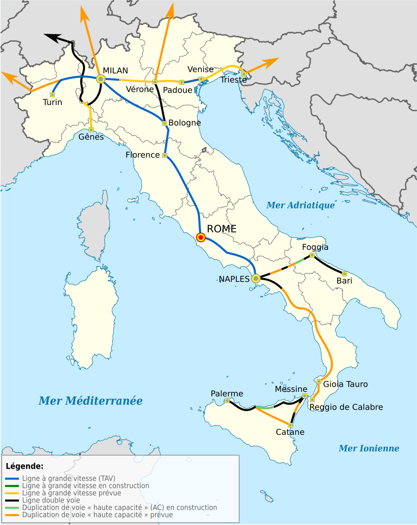
Deutsch: Hochgeschwindigkeitsstrecken in Italien auf der Positionskarte von Italien Quadratische Plattkarte, N-S-Streckung 132,898 %. Geographische Begrenzung der Karte:* N: 47.4° N * S: 35.3° N * W: 6.2° O * O: 19.0° O English: Hi-speed railway lines in Italy on Location map of Italy Equirectangular projection, N/S stretching 132,898 %. Geographic limits of the map: * N: 47.4° N * S: 35.3° N * W: 6.2° E * E: 19.0° E Italiano: Mappa di localizzazione dell'Italia
Proiezione equirettangolare, allargamento N/S 132,898 %. Limiti geografici della mappa: * N: 47.4° N * S: 35.3° N * W: 6.2° E * E: 19.0° E Français : Lignes ferroviaires principales (haute vitesse) en Italie, sur une carte géolocalisée du territoire italien Projection équirectangulare (N/S 132,898 %). Limites géographiques de la carte: * N: 47.4° N * S: 35.3° N * W: 6.2° E * E: 19.0° E |
| Date | (UTC) |
| Source |
Ce fichier est dérivé de : |
| Auteu |
Cette image vectorielle SVG non W3C-spécifiée a été créée avec Inkscape . |
| Autres versions |
 |
| Attribution (imposé par la licence) | © Domaina / Wikimedia Commons / |


W3C-validity not checked.
| Cette image a été retouchée, ce qui signifie qu'elle a été modifiée par ordinateur et est différente de l'image d'origine. L'image d'origine se trouve ici : Italy location map.svg:
|

|
This SVG file contains embedded text that can be translated into your language, using any capable SVG editor, text editor or the SVG Translate tool. For more information see: About translating SVG files. |
Licince
Ech fichié-lo il est disponibe slon chés térmes del licince Creative Commons Attribucion - Partage dins chés meumes Conditions 3.0 (poin transposée).
Attribution: Domaina
- Os ètes libe :
- éd partager – éd copier, distribuer pi transmète chole euve
- d’adapter – éd modifier chole euve
- Dsous chés condicions suivantes :
- patérnitè – Os d'vez donner chés informacions appropriées concernant l'auteu, fournir un loyen vers el licince, et indiquer si des modificacions ont tè foaites. Os povez foaire cha pèr tout moéyin raisonnabe, mais poin d'eune manière qui suggérerait qu’il vos soutienne o approuve l'utilisacion éq vos in foaites.
- partage à l’idintique – Si os modifiez, transformez, o os basez édseur chole euve, os d'vez distribuer vote contérbuchon dsous el meume licince o eune licince compatibe aveuc chole éd l'original.

|
Os avez l' pérmission d' copier, distribuer pi modifier chol documint slon chés térmes del GNU Free Documentation License vérsion 1.2 obin toute vérsion ultérieure publièe pèr el Free Software Foundation, sans sékcions inaltérabes, sans teske d' prumière pache d' couvérture pi sans teske ed darène pache d' couvérture. Un egzimploère del licince est inclus dins l' sékcion intitulée GNU Free Documentation License. |
Journal des téléversements d’origine
This image is a derivative work of the following images:
- File:Italy_TAV.png licensed with Cc-by-sa-3.0-migrated, GFDL
- 2010-02-23T20:45:36Z Pcongre 611x713 (37248 Bytes)
- 2008-12-16T18:42:12Z KevinCuddeback 611x713 (37133 Bytes) Reverted to version as of 18:41, 16 December 2008
- 2008-12-16T18:41:42Z KevinCuddeback 611x713 (39524 Bytes) Reverted to version as of 13:15, 13 April 2007
- 2008-12-16T18:41:21Z KevinCuddeback 611x713 (37133 Bytes) {{Information |Description= |Source= |Date= |Author= |Permission= |other_versions= }}
- 2008-12-16T18:37:24Z KevinCuddeback 611x713 (37133 Bytes) {{Information |Description= English: {{en|Hi-speed railway lines in Italy}} {{de|Hochgeschwindigkeitsstrecken in Italien}} |Source= own, revision of earlier work by {Sinigagl|user:Sinigagl} |Date= 2008-12-16 |Author=Sinigag
- 2007-04-13T13:15:01Z Sinigagl 611x713 (39524 Bytes)
- 2006-09-28T14:56:27Z Sinigagl 611x713 (39469 Bytes) == Dettagli == {{Information| |Description=Hi-speed railways in Italy |Source=own |Date=28.09.2006 |Author=Sinigagl |Permission= |other_versions= }} == Licensing == {{GFDL}} [[Category:Maps of Italy]]
- File:Italy_location_map.svg licensed with Cc-by-sa-3.0, GFDL
- 2010-09-11T06:42:56Z Citypeek 1034x1299 (1484466 Bytes) Made one layer of the entire picture. Better for adding new stuff.
- 2009-08-22T09:58:43Z Erinaceus 1034x1299 (1470342 Bytes) updating borders after important variation (http://www.gazzettaufficiale.it/guridb/dispatcher?service=1&datagu=2009-08-14&task=dettaglio&numgu=188&redaz=009G0127&tmstp=1250276942469)
- 2009-05-06T12:38:21Z NordNordWest 1034x1299 (1035834 Bytes) corr
- 2009-03-12T18:27:05Z NordNordWest 1032x1267 (1032937 Bytes) corr
- 2008-07-06T16:30:54Z NordNordWest 1032x1267 (1034196 Bytes) {{Information |Description= {{de|Positionskarte von [[:de:Italien|Italien]]}} Quadratische Plattkarte, N-S-Streckung 130 %. Geographische Begrenzung der Karte: * N: 47.4° N * S: 35.3° N * W: 6.2° O * O: 19.0° O {{en|Locat
Téléversé avec derivativeFX
Histoère dech fichié
Buke su eune date/heure pou vir ch'fichié conme il étoait ach momint-lo.
| Date/Tans | Tiote image | Diminsions | Uzeu | Fichié éd chés conmints | |
|---|---|---|---|---|---|
| courant | 20 d'Avri 2013 à 16:45 | | 1 034 × 1 299 (1 016 kio) | Citypeek | Cleanup of file. Valid SVG now. |
| 4 d'Aout 2012 à 08:10 |  | 1 034 × 1 299 (883 kio) | Domaina | == {{int:filedesc}} == {{Information |Description= {{de|Hochgeschwindigkeitsstrecken in Italien auf der Positionskarte von Italien}} Quadratische Plattkarte, N-S-Streckung 132,898 %. Geographische Begrenzung der Karte: * N: 47.4° N * S... |
Usage dech fichié
Autchune pache n'est loïée aveuc ch'fichié-lo
Usage global du fichier
Chés eutes wikis suivants uzette chole fichier :
- Utilisacion édseur en.wiktionary.org
- Utilisacion édseur es.wikipedia.org
- Utilisacion édseur fr.wikipedia.org
- Utilisacion édseur ru.wikipedia.org
- Utilisacion édseur uk.wikipedia.org
- Utilisacion édseur www.wikidata.org